


Trip Overview
-
 Trip Duration 16 Days
 -
 Destination Nepal
 -
 Accomodation Included
 -
 Max. Altitude 4900 Meters
 -
 Group Size 2 +
 -
 Best Season March, April, May, Sep, Oct & Nov
About the Trip
The Humla Chang La Valley Trek is a relatively new and off-the-beaten-path trekking route in the Humla district of Nepal. The trek starts from the town of Simikot, which is accessible by a short flight from Nepalgunj. From Simikot, the trail leads eastwards towards the villages of Thehe and Dozam.
As you continue on the trek, you will follow the Chang River through lush valleys that are rich in medicinal forest products and are home to various wild animals. One of the highlights of the trek is the enigmatic view of Changla, which stands at an impressive height of 6,900 meters. The pristine lakes and peaks in the periphery of Changla are another attraction that draws trekkers to this region.
This trek is ideal for those seeking a remote and less-traveled route in Nepal. The region is rich in cultural and natural diversity, with stunning views of the Himalayas, alpine forests, and traditional villages.
Included
- Airport transfer picks up and drops
- Hotel accommodation in Kathmandu and Nepalgunj with breakfast (Twin sharing)
- Domestic airfare (Kathmandu-Simikot-Kathmandu)
- Accommodation during the trek (Guest house) Experienced English speaking local trekking guide, assistant trekking guide and local porter(s) along with their flights, salary, lodging, food and insurance
- Trekking permits and all necessary paperwork
- Breakfast, Lunch and Dinner during the trek (with tea and coffee)
- First aid Medical kit
- Transportation on private vehicle as agreed on the itinerary
Excluded
- Your Nepal entry visa fee
- All kinds of beverages (soft/hard)
- Travel insurance and emergency evacuation expenses
- Extra baggage charges in domestic flights
- All entrance fees during KTM sightseeing
- Additional day accommodation expenses
- All personal expenses
- Tips for guides and porters
Day to Day Itinerary
-
Day 01:Arrival Kathmandu – transfer hotel – tour briefing
-
Day 02:Flight from Kathmandu to Nepalgunj (150 m), 1 Hr.
-
Day 03:Flight from Nepalgunj to Simikot (2950 m), 45 Minutes.
-
Day 04:Trek from Simikot to Dojam (2,480 m) 5 Hrs.
-
Day 05:Trek from Dojam to Tumling Khola (3,500 m) – 6-7 Hrs.
-
Day 06:Trek Tumling Khola to Lor Khola (4,000 m) – 5-6 Hrs.
-
Day 07:Trek to Gurukpa (4,150m/13,612ft) – 5-6 Hrs.
-
Day 08:Acclimatization day at Gurukpa (Excursion to Chang Valley)
-
Day 09:Trek from Gurukpa to Phyajang Base Camp (4,700 m) – 6-7 Hrs.
-
Day 10:Trek from Phyajang BC to Nying Khadka (4,500 m) via Nying La Pass (5,448 m) 6-7 Hrs.
-
Day 11:Trek from Nying Khadka to Talung (4300 m), 5-6 Hrs.
-
Day 12:Trek from Talung to Shingjungma (3800 m), 5-6 Hrs.
-
Day 13:Trek from Shingjungma to Lek Dhinga (3681 m), 6-7 Hrs.
-
Day 14:Trek from Lek Dhinga to Simikot
-
Day 15:Flight from Simikot to Kathmandu (Connecting flight from Nepalgunj (one hour 45 minutes
-
Day 16:
Detail Itinerary
Day 01:Arrival Kathmandu – transfer hotel – tour briefing
Upon arrival at Kathmandu airport, which sits at an elevation of 1,302 meters or 4,270 feet, our staff will be waiting to receive you and will escort you to your hotel. After settling in, you can take some time to refresh yourself or explore the surrounding area before accommodating in your hotel.
Day 02:Flight from Kathmandu to Nepalgunj (150 m), 1 Hr.
You will be transported to the airport to catch a flight to Nepalgunj. If the weather is clear, you will be able to enjoy spectacular views of the Himalayan range during the flight. Upon arrival in Nepalgunj, our staff will be waiting to escort you to your hotel. Nepalgunj is located in the Terai region and can get quite hot during the summer months. You will have the afternoon free to explore Nepalgunj or simply relax at the hotel. We will spend the night at the hotel before continuing our journey
Day 03:Flight from Nepalgunj to Simikot (2950 m), 45 Minutes.
We will be transported to the airport to catch a flight to Simikot, which takes approximately 45 minutes. En route, we will enjoy stunning views of snow-capped mountains. Upon arrival, we will walk to our lodge, leaving our luggage there, and explore the village. Simikot is a small district headquarter of Humla with a majority of its population following the Hindu religion, and it is well worth staying overnight here. Since Simikot is situated at a 2910 msl altitude, it is a good idea to spend the night here to allow your body to acclimatize.
Day 04:Trek from Simikot to Dojam (2,480 m) 5 Hrs.
Leaving Simikot, we will begin our trek with the strong team and mules loaded with camping gears and equipment and guest’s Duffel Bags towards Dojam via Thehe village. Dojam will be the last village for a couple of weeks. There will be no permanent human settlement above Dojam but we will meet Yak herders and shepherd’s huts in different valleys.
Day 05:Trek from Dojam to Tumling Khola (3,500 m) – 6-7 Hrs.
Following the bank of Chuwa Khola and crossing Ghatte Khola to reach the confluence of Tumling Khola is sure to provide some beautiful scenery. Setting up camp at Syamboyak and exploring the wildlife in the area, such as the blue sheep, is a great way to fully experience the natural beauty of the region. Just be sure to follow proper safety guidelines and regulations to ensure the well-being of both yourself and the wildlife.
Day 06:Trek Tumling Khola to Lor Khola (4,000 m) – 5-6 Hrs.
Following the left bank of Chuwa Khola, the trail goes uphill through alpine vegetation and enters the widening rocky valley of Dhyualing. Further walking, we will reach the confluence of Lor Khola. The rest of the day is free for excursions to Lor Khola Valley.
Day 07:Trek to Gurukpa (4,150m/13,612ft) – 5-6 Hrs.
Leaving Lor Khola, we will cross the river and follow the right bank of Chuwa Khola till Gurukpa or Karching Kharka. Gurukpa is the confluence point of NingKhola and Chuwa Khola. At Gurukpa, the track divides. The right one leads to the Chang La Border pass (5,293) to Tibet.
Day 08:Acclimatization day at Gurukpa (Excursion to Chang Valley)
As per the study on high altitude sickness, it has been found that most people suffer or show signs of Acute Mountain Sickness (AMS) from the altitude of 14,000 ft. Thus it is highly recommended to have a rest day to acclimatize at this altitude before starting an ascent. On this day, we will do some day hikes to the nearby hills.
Day 09:Trek from Gurukpa to Phyajang Base Camp (4,700 m) – 6-7 Hrs.
Taking the left route, we will follow NingKhola and enter a side valley to cross Nying La Pass. We will stopover at the bank of the river at an elevation of 4,700m and prepare to cross the high pass. The trail passes through the rocky terrain.
Day 10:Trek from Phyajang BC to Nying Khadka (4,500 m) via Nying La Pass (5,448 m) 6-7 Hrs.
Early breakfast and start trek to cross the transverse of Nying La Pass of elevation 5,448m. It is possible to cross the pass from June to September. In the remaining months, it may be covered by snow. The trail ascends gradually until we reach the high pass. Exploring the view from the pass, we will descend to Nyingkhola Valley and trek through the bank of the river, and set up camp at an elevation of 4,600m.ereas the left one leads to Ning Valley Route.
Day 11:Trek from Nying Khadka to Talung (4300 m), 5-6 Hrs.
Today’s trek is longer than the previous days, so we will start early after having breakfast. We will leave the Limi valley and all the Tibetan villages behind and continue trekking towards Talung. The trail gradually ascends through impressive, desolated landscapes, and we will have to cross rivers several times. The thin air may also slow down our pace. We will continue trekking until we find a suitable camping site near a talung river where we can camp for the night.
Day 12:Trek from Talung to Shingjungma (3800 m), 5-6 Hrs.
Today’s trek is a challenging and unforgettable one, as we hike to the highest point of our journey. Initially, the trail is flat and we cross a few rivers, but must be cautious due to frozen stones. The steep climb to the pass is difficult, but reaching the summit rewards us with stunning 360-degree views of Humla and Tibet, including Mount Saipal and Mount Kailash. Descending steeply, we reach Lake Selma Tso before continuing down the Sali River to our Shinjungma campsite for the night.
Day 13:Trek from Shingjungma to Lek Dhinga (3681 m), 6-7 Hrs.
The trek from Singjungma to Lekdhina offers a stunning path that leads to a magnificent trail we must traverse, known as Sheji Pass, which stands at an altitude of approximately 4600 meters. After descending from the pass, we arrive at Lek Dhinga, where the local Dhinga and Hepka communities have their summer houses. This will be our campsite, and we can enjoy the breathtaking views of the surrounding area from Lek Dhinga.
Day 14:Trek from Lek Dhinga to Simikot
After having breakfast, we will begin our journey towards Simikot, where we will spend our final night and conclude our trek.
Day 15:Flight from Simikot to Kathmandu (Connecting flight from Nepalgunj (one hour 45 minutes
We will take an early morning flight from Simikot to Nepalgunj, followed by a connecting flight to Kathmandu on the same day. Tonight, we will have a dinner party together to celebrate our successful trek and enjoy our time with the entire team.
Day 16:
Our final departure will be from Kathmandu, where we will bid farewell to each other. It has been a pleasure to serve you, and we look forward to the opportunity to do so again in the future. Thank you for choosing us for this unforgettable trekking experience.
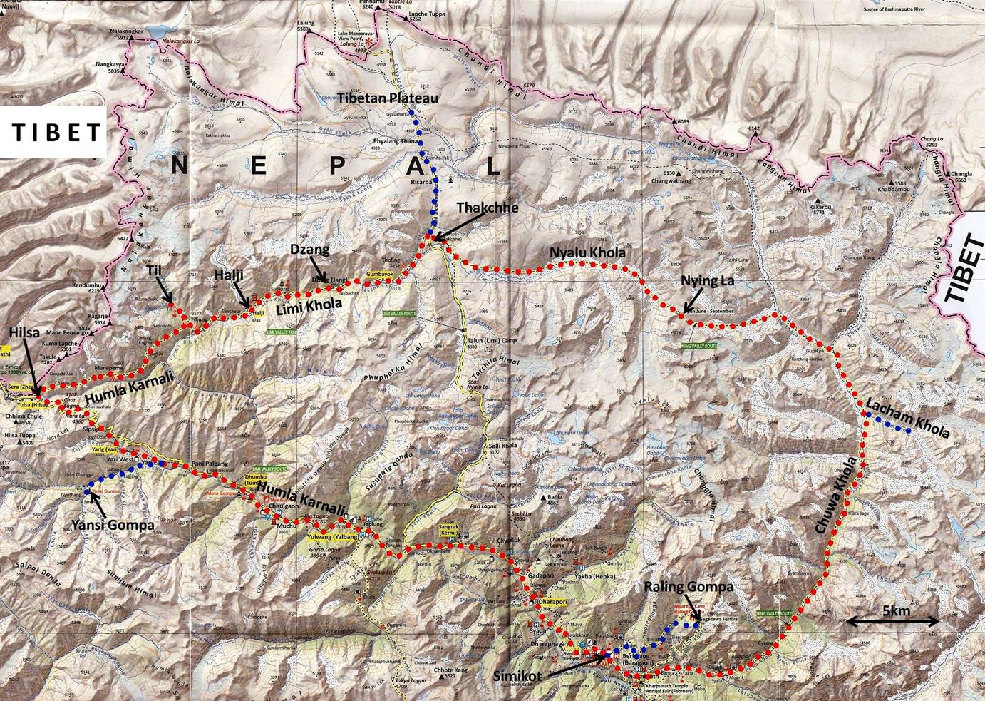
Trip Map
16 Days
Book This Trip
Customize This Trip
Ask Question
24x7 Booking Support (Call, WhatsApp) 9841549864
We are Proudly Associated with


Popular Trekking
© 2026 | Smiling Eyes Intl All rights reserved.
Terms and Conditions |
Contact |
